How to use a GPX file on your phone
Every trail on this site comes with a free GPX file: the line Kay walked, saved as GPS points. Load it into a map app and your phone shows the trail and your blue dot on it, even deep in the jungle with no signal. Here is how, for the apps Malaysian hikers actually use.
Which app should I use?
| App | Offline map | Good for |
|---|---|---|
| Organic Maps | Free | Free and simple, no account |
| Wikiloc | Free | Offline trail navigation |
| Gaia GPS | Premium | Detailed topo maps |
| AllTrails | Plus | If you already use it |
| OsmAnd | Free, limited | Power users |
Step 1 · Download the GPX
Open the trail
Go to Free GPX or any trail page and tap Download GPX. On trails with more than one route, tap Choose a route first.
Find the file
iPhone: Files app → Browse → iCloud Drive → Downloads, or the downloads button in Safari. Android: Files app → Downloads.
If the GPX opens as a page of text, that's normal. Go back, find it in Downloads, then use Share (iPhone) or Open with (Android).
Step 2 · Import it into your app
Tap your app for the steps.
Organic MapsFree · offline maps free
Free, no account, and the offline maps are free. The easiest pick when the trail has no signal.
- Download the offline map for the area first (at home, on Wi-Fi).
- Find the GPX in Files or Downloads and tap it.
- iPhone: tap Share and choose Import with Organic Maps. Android: choose Open with Organic Maps.
- You'll see Bookmarks loaded successfully! The trail line now sits on the map with your blue dot.
Works with every GPX on this site: Organic Maps reads both track files and route files (Suunto exports). Checked in its open-source code, 30 Sep 2026. It shows the line and your position; follow the line by eye.
Gaia GPSImport on phone · offline maps need Premium
The app in Kay's original guide. The free plan shows the trail and your location, but only Premium can download maps for offline use.
- Sign up for a free account in the app.
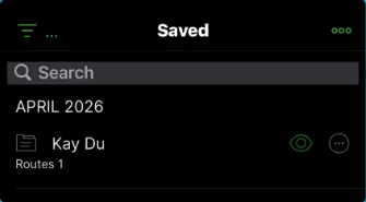
- Tap Saved at the bottom.
- Tap the 3 dots at the top right.
- Tap Import File and pick the GPX you downloaded.
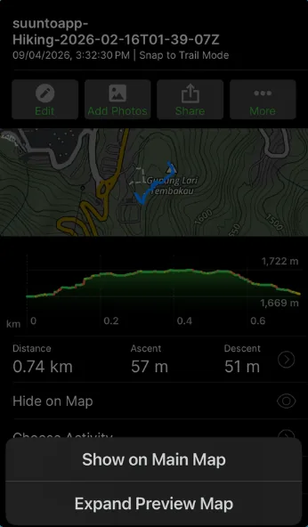
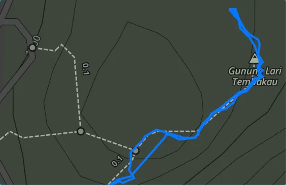
- Tap the imported item, tap the map, then choose Show on Main Map.




WikilocOffline maps free · some navigation is Premium
A large hiking community app. Wikiloc says its offline maps are free; navigating other people's trails needs Premium (14-day free trial).
- Find the GPX on your phone.
- iPhone: tap Share and choose Wikiloc. Android: tap the file, Open, then Wikiloc.
- Open the trail, tap Available Offline and download the offline map.
- On the day, tap Navigate Trail. Airplane mode is fine once the map is saved.
AllTrailsUpload on phone · offline maps need Plus
You can upload a GPX in the app or on alltrails.com (files up to 20 MB). Offline maps are an AllTrails Plus feature.
- Tap Saved.
- Under Lists, tap Custom routes.
- Tap the 3 dots, then Upload route, and pick the GPX.
OsmAndFree: 7 map downloads on Android, 5 on iPhone
Powerful and free up to a limit of map downloads (7 on Android, 5 on iPhone; an update counts as one).
- Tap the GPX and choose Open in OsmAnd. It lands in the Import folder in My Places.
- Open the track, then Navigation, and follow the track.
About half of Kay's files store the line as a route (Suunto exports). OsmAnd treats route points as stops and can calculate a new path between them. Follow the recorded line itself, not a recalculated route.
Hiking with a watch
- Suunto app: Open the Map view, tap +, then Import route (.gpx), pick the file, name it and save. Sync to your watch.
- Amazfit (Zepp app): Open the GPX with the Zepp app, save the track, then send it to your watch. On the watch: Navigation → My Route.
- Garmin: Garmin imports GPX files as courses in Garmin Connect. Follow Garmin's own guide for your watch.
Step 3 · Before you leave home
- Download the offline map for the trail area on Wi-Fi.
- Open the trail in the app once to check the line shows up.
- Allow the app to use your location.
- Charge your phone and bring a power bank.
- Check if the trail needs a permit. For Selangor, see how to get a hiking permit.
Step 4 · On the trail
- Keep your blue dot on the line. If you drift away from it, walk back to the last point where you were on the line.
- Turn off mobile data, Wi-Fi and Bluetooth, or use airplane mode, to save battery. GPS keeps working.
- Use Google Maps only to drive to the start, with the Meeting Point button on each trail. It can't navigate a GPX trail.
- A GPX shows the way Kay walked on the day. Trails change, so watch the ground and markers too.
Questions
What is a GPX file?
A small file that stores the line of a hike as GPS points. Load it into a map app and you can see the trail and where you are on it.
Does the GPX work without phone signal?
Yes, if you prepare. Your phone's GPS works without mobile data, because it reads satellites. The map background only shows offline if you downloaded the offline map first, so do that at home on Wi-Fi.
Which app is best for Malaysian jungle trails with no signal?
Organic Maps is free and its offline maps are free. Wikiloc's offline maps are free too. Gaia GPS and AllTrails need a paid plan for offline maps.
Can Google Maps open a GPX file?
Google Maps can't navigate a GPX trail, and Google says walking directions are not available offline. Use Google Maps only to drive to the trailhead with the Meeting Point button, then switch to a hiking app.
Where does the GPX go after I download it?
On iPhone: Files app, Browse, iCloud Drive, Downloads, or the downloads button in Safari. On Android: the Files app, Downloads.
The file opened as a page of text. What now?
That's the raw GPX. Go back, find the file in Downloads, then use Share (iPhone) or Open with (Android) and pick your hiking app.
Do I need an account?
Not for downloading from this site. Some apps, such as Gaia GPS, ask you to sign up for a free account before you import.
Sources, checked 30 September 2026: Gaia GPS: Import GPX into the iOS app · Gaia GPS: Membership options · Organic Maps: How to import bookmarks and tracks · Organic Maps GPX parser (source code) · Wikiloc: Navigate a trail offline · Wikiloc: Download offline maps · AllTrails: Uploading files · AllTrails: Premium membership · OsmAnd: Manage tracks · OsmAnd: Navigate by track · Suunto: Import a .gpx in the Suunto app (iOS) · Apple: Where to find downloads on iPhone · Google: Download areas and navigate offline. App menus and prices change, so check the app's own help if a step looks different.